

Read the letter first
A civic address with a letter in front of the number almost always means that more than one dwelling is associated with what was once a single numbered parcel. The letter is assigned by the municipality so that post, emergency services and utilities can tell the dwellings apart. It is an addressing decision, not an ownership one, and that distinction is where buyers get caught: two properties with the same number and different letters can sit on one strata plan, on one bare-land strata plan, on a duplex parcel, or on two entirely separate fee-simple lots created by a later subdivision. All four look identical from the road.
Which of those four applies decides almost everything that follows — what you own outright, what you own a share of, whether there are monthly fees, whether there is a council whose decisions bind you, what you may build or alter without anyone else's agreement, and how a lender will treat the purchase. OpenStreetMap records a separate address point for 3876A on this street as well, about 67 metres away by our calculation from the coordinates read on 8 October 2026, so there are at least two lettered dwellings here rather than one.
The answer is on title, in the land title register, and it is not inferable from the address, from a photograph or from any listing field. It takes one title search to establish, I order it as a matter of course, and it should be settled before an offer rather than during a subject-removal period. If the register shows a bare-land strata, our bare-land strata guide explains what that form actually commits an owner to, which differs from a conventional strata in ways that surprise people.
The questions a lettered address creates
Assume nothing is shared until the register says it is not, and assume nothing is exclusive until the register says it is. The driveway is the usual flashpoint: where two dwellings reach the road over one surface, the right to use it is either a registered easement, common property under a strata plan, or an informal arrangement between neighbours that binds nobody. The third kind is the one that fails, and it fails at the worst moment, when one of the two sells.
Then the services. Water, sewer or septic, hydro and gas may each run to one dwelling or be shared between the two, and a shared service line raises the question of who pays to repair it. Then insurance, which is written differently for a strata lot than for a fee-simple house and differently again for a half-duplex. Then the parking, the refuse collection point, and whether any part of what the occupant treats as their garden is actually limited common property allocated for their use rather than land they own.
None of these are reasons to walk away. Lettered addresses on shared lots are ordinary, they are frequently good value against a comparable whole-lot house, and the questions all have answers. They just have to be asked before the money moves. The same logic applies at scale across the region, which is why strata versus freehold is one of the first things worth reading if this is a form of ownership you have not held before.
Where this one sits on the street
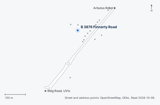
Finnerty Road runs between Ring Road at the University of Victoria campus and Arbutus Road, and this address is in the upper third of it: roughly 317 metres from the Arbutus Road junction and 507 metres from the Ring Road junction, which is our calculation from the OpenStreetMap coordinates. It is a paved tertiary road with sidewalks on both sides along this stretch and a 40 km/h posted limit.
Taking the nearest places in turn, all straight-line from this address and all calculated by us from the same OpenStreetMap data rather than quoted from anywhere: Haro Woods Park at about 401 metres, Montague Park at about 554 metres, the main university campus area beginning at about 738 metres, Goward Park at about 740 metres, the university's Queenswood campus at about 827 metres, Mystic Vale at about 1,108 metres and Finnerty Gardens at about 1,228 metres. A real walk to any of them is longer than the straight line, by an amount that depends on the route.
Municipal and provincial rules for a lot in this pocket are the same ones that apply up the road, and the Gordon Head neighbourhood guide sets out the plans adopted in 2024 and 2026 that govern what can be built nearby. For a lettered address there is one extra wrinkle worth naming: the provincial small-scale multi-unit rules that have applied in Saanich since 30 June 2024 are expressed per lot, so what they permit depends on the parcel the title search reveals, not on the civic address. SaanichMap is where the municipality publishes the answer, lot by lot. The wider market context is on the Saanich real estate page.
Where this page's facts come from
Street geometry, address points and the distances below come from OpenStreetMap data read on 8 October 2026 (© OpenStreetMap contributors, Open Database Licence). Distances are our calculation from those coordinates: straight-line from this address to the centre of the named place, not walking distance and not driving distance.
Nothing on this page is taken from a listing. Comparable sales come from VREB Matrix and are discussed in person, not published here. Municipal plans, bylaws and assessment records change; the links below go to the authorities that publish them, and those are the current versions. Read 2026-10-08.
Amit Khatkar is the listing REALTOR® for this property through eXp Realty. DDF Rules s.5(m) preserves a participant's right to publish information about their own listings created by them or obtained independently of the DDF. Everything written on this page was obtained independently of the DDF.
- OpenStreetMap: Finnerty Road centrelines and address points (© OpenStreetMap contributors, ODbL)
- Land Title and Survey Authority of British Columbia: title searches
- District of Saanich: small-scale multi-unit housing
- SaanichMap: zoning, development permit areas and Urban Containment Boundary by address
- BC Assessment: property assessment search